Getting Around Boston: A Guide for Fort Hill Inn Guests
- Nov 15, 2025
- 4 min read
Updated: Dec 2, 2025
One of the biggest advantages of staying at Fort Hill Inn is how easy it is to get around Boston from our quiet, historic neighborhood. Whether you’re heading to a museum, a business meeting, a medical appointment, a campus tour, or a day of sightseeing, you’ll have quick access to the subway, buses, bikes, rideshares, and major roads.
This guide gives you everything you need: transportation tips, airport access, subway routes, and simple walking directions to the inn.
1. Fort Hill Inn’s Location: Central, Convenient, Connected
Fort Hill Inn is located at: 3 Centre PlaceBoston, MA 02119
The neighborhood is peaceful, historic, and residential. Yet only 1.5 miles from Copley Square, one of Boston’s busiest and most visited districts.
From Fort Hill Inn, you can reach:
The center of the city attractions – 3 stops away
Back Bay – ~5 minutes by subway
Longwood Medical Area – 10 minutes
Northeastern University – 10 minutes
Museum of Fine Arts – 12 minutes
Fenway – easy transfer on the Green Line
The location offers the perfect balance of quiet and accessibility.
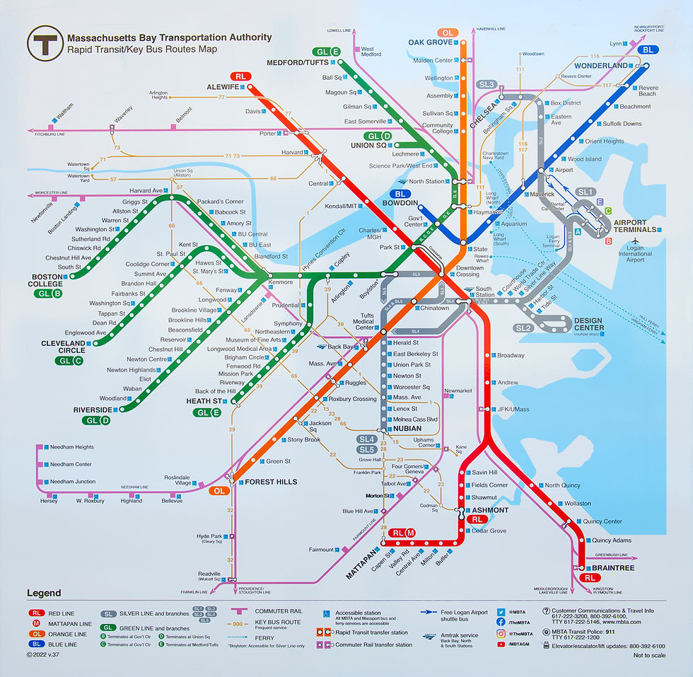
2. The Subway (MBTA) — The Fastest Way to Explore Boston
The Boston subway system, known locally as the T, is the quickest and easiest way to travel between neighborhoods.
Roxbury Crossing Station — Less Than a 5-Minute Walk
Fort Hill Inn is just a short walk to Roxbury Crossing on the Orange Line.
Travel Time to the Center of the City Attractions
5-minute ride
3 stops to Back Bay
4 stops to Downtown Crossing
From there, you can connect to the Red Line, Green Line, Silver Line, and commuter rail.
Easy Access to Popular Boston Attractions
From Roxbury Crossing, you can reach:
Back Bay Station – shops, dining, Copley Square
Chinatown
Theater District
Park Street – Boston Common, Public Garden
Haymarket – North End
North Station – TD Garden
Bikes for Rent
Bluebikes (Boston’s public bike-share) are available right at the subway station, perfect for scenic rides along the Charles River or through the Emerald Necklace parks.
3. By Bus — Over 15 Bus Lines Serve the Area
Fort Hill is extremely well served by MBTA bus routes. More than 15 bus lines pass through the surrounding streets, connecting you to:
Longwood Medical Area
Northeastern University
Museum District
Back Bay
Downtown
Cambridge
Jamaica Plain
South End
Logan Airport (with transfers)
For route maps, schedules, and trip planning, visit the MBTA website.
4. Getting to Fort Hill Inn from Logan Airport
Boston Logan International Airport is conveniently close to Fort Hill Inn, only 4–5 miles away.
Depending on traffic and your preferred method of travel, it’s:
20 minutes by car or rideshare
30–45 minutes by subway
Below are detailed step-by-step directions for both options.
5. Driving Directions From Boston Logan Airport
If you’re driving or taking a taxi/Uber/Lyft, follow these directions:
Start on Harborside Drive toward Hotel Drive.
Continue onto Harborside Drive, which becomes Transportation Way.
Merge onto I-90 West / Ted Williams Tunnel (toll).
Take Exit 25–24 toward I-93 / South Boston.
Merge onto I-93 South via Exit 24 on the left.
Take Exit 18 toward Mass Ave / Roxbury.
Merge onto Mass Ave Connector.
Continue straight onto Melnea Cass Boulevard.
Turn left onto Tremont Street.
Go through 4 traffic lights.
Look for RCC (Roxbury Community College) on the left and Domino’s Pizza on the right.
At the next light, turn left and go up the hill.
Take the first left, then the first right onto Centre Place.
Fort Hill Inn — 3 Centre Place — will be on the right.
6. Getting From Logan Airport by Subway
If you prefer public transit, Boston’s subway system makes the trip simple.
Step-by-Step:
Follow signs to the Massport Shuttle from airport arrivals.
Take the shuttle to the Blue Line Airport Station.
Board the Blue Line inbound toward Bowdoin.
Get off at State Street.
Transfer to the Orange Line toward Forest Hills.
Get off at Roxbury Crossing.
From the station, it’s just a short walk to the inn.
7. Walking Directions From Roxbury Crossing Station
From Roxbury Crossing:
Turn right when you exit the station.
Cross Columbus Avenue toward the brick building with the black handrail (Roxbury Community College).
Cross the courtyard with the three tall flagpoles.
Continue straight toward Gardner Street — the steep hill.
Walk up Gardner to the top.
Gardner ends at Centre Street — turn right.
Walk past Harrington.
The next street on the right is Centre Place.
Fort Hill Inn (3 Centre Place) is on the right with the flags.
This walk takes about 4–5 minutes.
8. Rideshares & Taxis
Fort Hill Inn is fully accessible by:
Uber
Lyft
Local taxi companies
Pickups and drop-offs are simple since Centre Place is a small residential street.
9. Do You Need a Car? Probably Not.
Boston is one of the most walkable and subway-friendly cities in the U.S.Most guests find they don’t need a rental car at all.
You may NOT need a car if you are:
Exploring museums, neighborhoods, and downtown
Visiting Northeastern, Wentworth, MassArt, MCPHS
Attending medical appointments
Staying for tourism or short business trips
You MAY want a car if you plan to:
Drive to Cape Cod
Visit the Berkshires
Explore outside Boston
Parking near Fort Hill Inn is residential and can be limited, so many guests choose rideshare or transit instead.
10. Explore Boston With Ease
Whether you prefer the subway, walking, biking, rideshare, or driving, Fort Hill Inn’s location makes getting around simple. You can reach nearly every major attraction, from the Museum of Fine Arts to the Freedom Trail, in minutes.
If you need personalized directions or help planning your route, just ask. We’re always happy to help you navigate Boston like a local.


Comments